
Twin Cities Severe Weather Threat for Thursday - May 12th

Tornado Watch has been issued for the Twin Cities until Midnight. I continue to monitor this squall line as it advances towards the Twin Cities region. It has not showed signs of weakening as of yet. There is a slight outflow boundary ahead of the line, but it does not seem that it has done much as far as any weakening of this line.
Primary threats include:
- A few tornadoes likely
- Widespread damaging winds and isolated significant gusts to 90 mph likely
- Scattered large hail likely with isolated very large hail events to 2.5 inches in diameter possible
———————————————————————
A quick update on our severe weather threat for this evening as of 4:30 PM.
Following an outflow boundary that worked across the Twin Cities metro from a cluster of storms working off to the east-northeast this morning, we have seen the skies clear allowing for our temperatures to really rebound this afternoon. Much of the metro has temperatures back in the upper 70s to low 80s. As you go further south, temperatures are even in the mid-80s to low 90s. As a warm front continues to work north this afternoon, we could see temperatures increase still a few more degrees along with a slight uptick in our moisture.
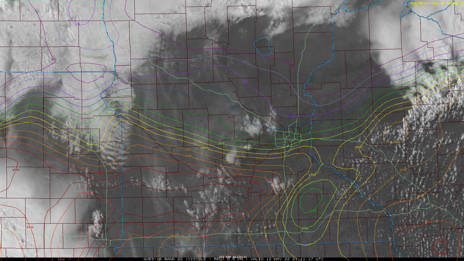
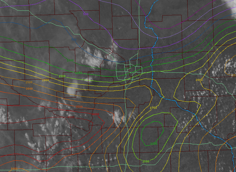
Above you will see a wide and close shot of the current satellite with CAPE layered on top of it. The lighter colors distinguish lower CAPE values while the brighter colors closer to red mean high CAPE values. For reference, we generally only need about 500 J/Kg of CAPE to support strong to severe storms. Across the metro, 750 to 2500 J/Kg of CAPE is available and I expected this to still increase some into the evening hours. So at this time, there should be a sufficient amount of instability in place to support the potential for strong to severe storms across the metro late this evening, but it appears before the line of storms arrives in the metro some of that instability could get washed out by another outflow boundary that could be shed by a cluster of storms that tracks to the northwest of the metro ahead of the main line.

This is the 1800 UTC model run for the HRRR model, one of a handful of models we use to forecast the weather. The above image shows a cluster of storms that are forecast to track close to the metro but stay just to the north-northwest by around 7-8 PM. This first round will need to be monitored, as I can’t rule out parts of the far northern and western suburbs seeing some strong to severe storms, but for most this should avoid the Metro. This first cluster appears to shed an outflow boundary, similar to what happened late this morning from the storms over St Cloud. That outflow boundary brought cool, dry air across the region which decreased both the moisture and temperature, which also briefly decreased the instability.
Some of the model guidance hints that this first round of storms could do a similar thing, which would be good for the Metro when a possible second round of storms works into the region from the west-southwest between 10 PM to 1 AM, which you can see below. The HRRR has this line weakening as it works towards the region. This is odd when you think there should be more than enough instability in front of this cluster to sustain it, but because of the outflow from the first round, the CAPE is decreased from over 1000 J/Kg to around 500 J/Kg for parts of the Metro. 500 J/Kg again is more than enough to sustain strong to severe storms, but they might not be AS strong as initially forecast.
How much of an impact this possible outflow makes will still need to be determined though, because we need to see how far that outflow boundary tracks, how strong it is, or if it even develops. For areas south of that possible outflow boundary, over 2000 J/Kg of CAPE could still be available, so some stronger storms could be possible in these areas if the storms are able to tap into that instability.
The main threat from this line will once again be large hail, damaging wind gusts, and possible flash flooding. While again low, can’t rule out the chance of a quick spin-up QLCS tornado as well.

While the guidance doesn’t show this, because it is a very mesoscale feature (small feature), showers and storms could also develop along and ahead of that outflow boundary as well since it is a source of lift. So that could also be something we need to monitor. Any storms that develop along the outflow boundary could pose a localized threat for large hail and damaging wind gusts. There could also be a localized threat of flooding depending on how slow those storms move. If this occurs, that could also take away from the instability but could be on a much smaller/more localized scale.
As always, be sure to have multiple ways of receiving severe weather alerts this evening and I will try to update this blog with any watches that might be issued across the region.