
Excessive heat returns to the Twin Cities Metro, Strong storms are possible
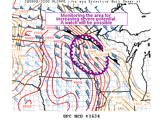
The Storm Prediction Center (SPC) has issued a mesoscale discussion and is monitoring conditions for the possible issuance of a watch. If storms develop and are persistent, they could have a threat for all severe hazards this evening, including large hail, damaging winds, and a tornado or two. There continues to be uncertainty in regards to if storms will develop or not. We will continue to monitor this activity and update this blog with a watch if one is issued.
The excessive heat has returned across the Twin Cities metro with forecast highs today expected to be in the mid to upper 90s. Add in the humidity and the heat index is forecast to be near 105F across the Twin Cities metro today. Below you will find the latest forecast from the 0600Z HRRR model with the first image being the forecast high temperature at 5 PM and the second image being the forecast max heat index at 6 PM.
The National Weather Service in the Twin Cities has issued an Excessive Heat Warning for the entire Twin Cities metro, including the counties of Hennepin, Anoka, Ramsey, Washington, Carver, Scott, and Dakota, from 1 PM this afternoon through 8 PM this evening due to the combination of extreme heat and humidity that is forecast across the region.
The record high temperature for Minneapolis-St Paul on August 2 is 99F, according to the National Weather Service, which was set back in 1988. There is a chance we could tie that record once again today! The normal high for this time of year is 83F.


Strong to Severe Storms Possible Today!


In addition to the extreme heat, there is also a Marginal risk (1 out of 5) for severe weather today across the Twin Cities region. There is a greater likelihood of these strong to severe storms to the north-northeast of the Twin Cities across Duluth, Minnesota and into Northern Wisconsin where a Slight risk (2 out of 5) is in place. The latest model guidance continues to struggle with how our strong to severe storm chances will unfold today, which is leading to a complex scenario across the region. There is a chance for a few rounds of showers and storms, with the first round possibly having an impact on the second round if it were to occur. In the second image above, you will see one possible model outcome for today showing isolated storm chases for this evening. This is the 0000Z run of the NAM 3km weather model. Of the models, this run here had the greatest chance for showers and storms across the metro, but this specific model is also known to over do precipitation chances and amounts in the past. So trends will need to be monitored throughout the day today.
Two fronts will play a role in our rain and storm chances today. The first will be a warm front that is forecast to lift north across the state this morning into the early afternoon reaching the Canadian-United States border by late afternoon. A few isolated showers and made a few storms can’t be ruled out as this front lifts north, but much of this activity should be elevated in nature. If a strong to severe storm were to develop, the main threat would be isolated large hail and damaging winds.
The second round of severe weather would come around/or after the 6 PM timeframe for the Twin Cities region as a cold front advances off to the southeast across the region. The latest guidance has the greatest chances for strong to severe storms across Duluth and into Northern Wisconsin, but a few isolated to scattered cells could develop along and ahead of that front as it works across the region. The main threat once again from these storms would be large hail and damaging winds. There will be an abundance of instability available for storms to work with if they can develop, the limiting factor though will be, can the storms develop. A CAP (or lid in the atmosphere) might be just strong enough to hold off the storms. This could result in a more isolated risk, or no storms at all. We will have to see if we can get enough lift to force through that possible CAP or if the CAP might be a little weaker than the models are anticipating.
Drought Threat Increasing

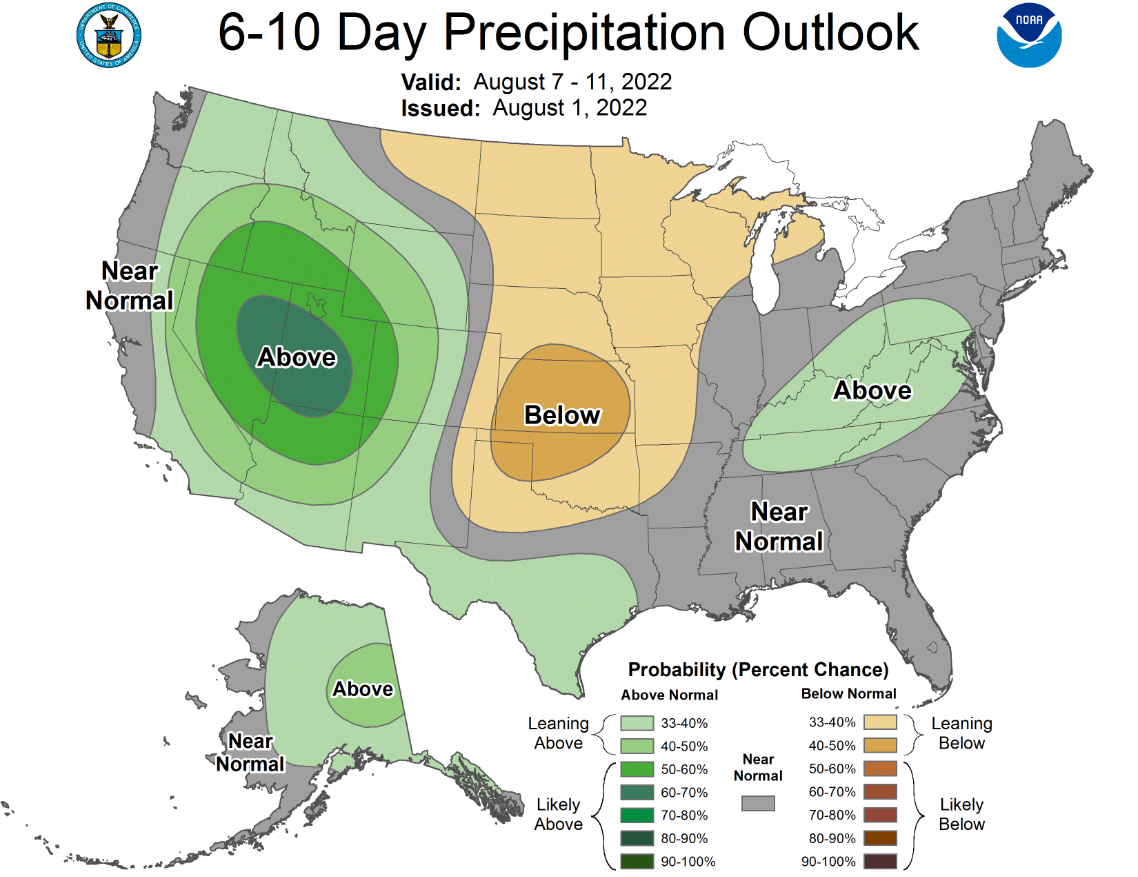
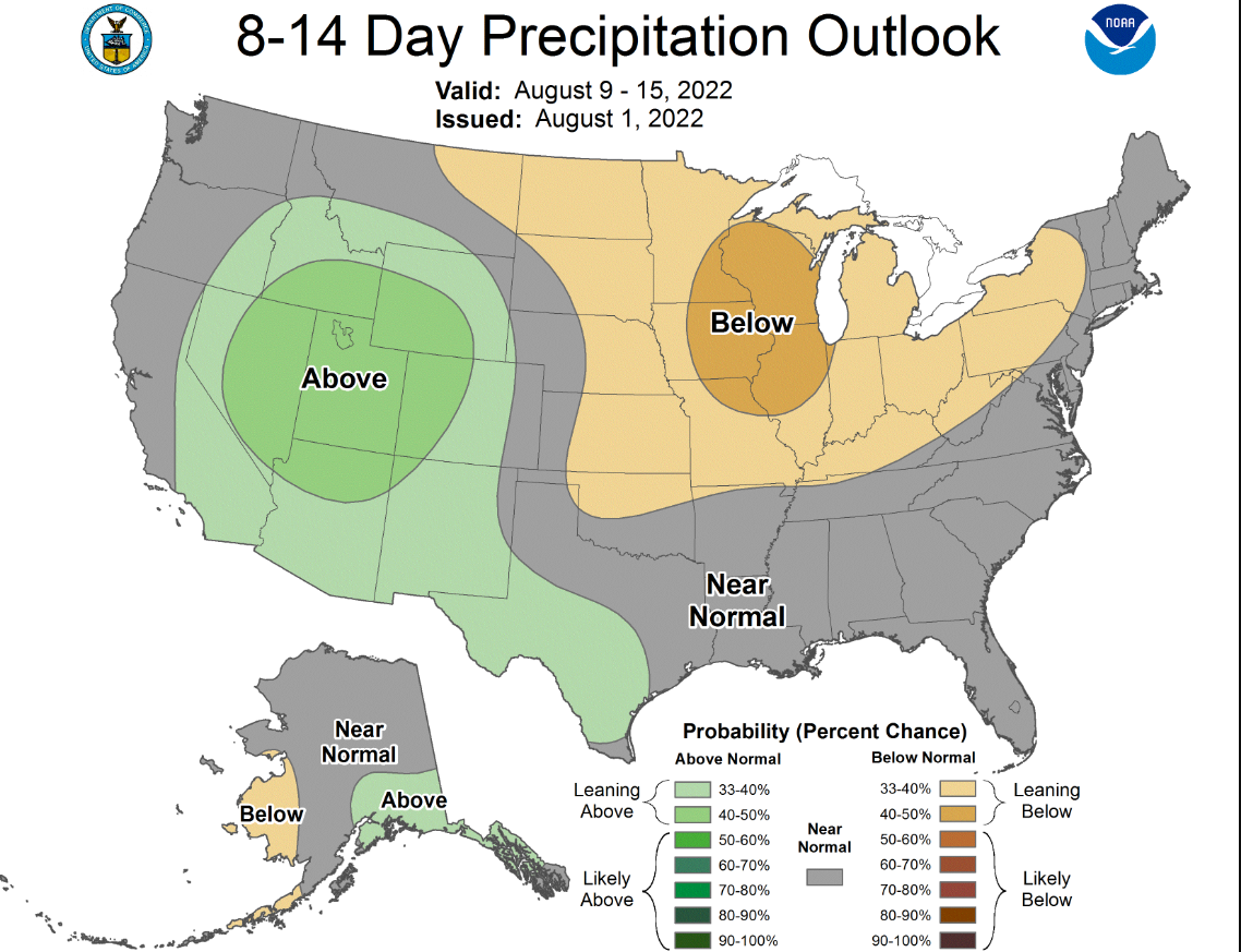
No one wants severe weather, but at the same time, the regional really needs the rain! The above chart is the latest U.S. Drought Monitor for the state of Minnesota as of July 26, 2022, at 8 AM. The next map will be issued at 7:30 AM CDT on Thursday. While we are in a much better place than where we were a year ago at this time, we are starting to see a return of moderate to severe drought across the Twin Cities region. Some minor rain could come today, with another slight chance of rain coming this weekend, but outside of that, we are forecasted to see a 33-40% chance of below-average precipitation through at least the next 10 days. Once we go out to 8-14 days, those chances of below-average precipitation increase to a 40-50% chance.
As always, be sure to have a plan in place in case severe weather does develop, and remember to be weather aware!