
Winter Weather Advisory Issued for Minnesota
Learn more about how your business can Sponsor the next Twin Cities weather update here: Advertise with Limitless Media!

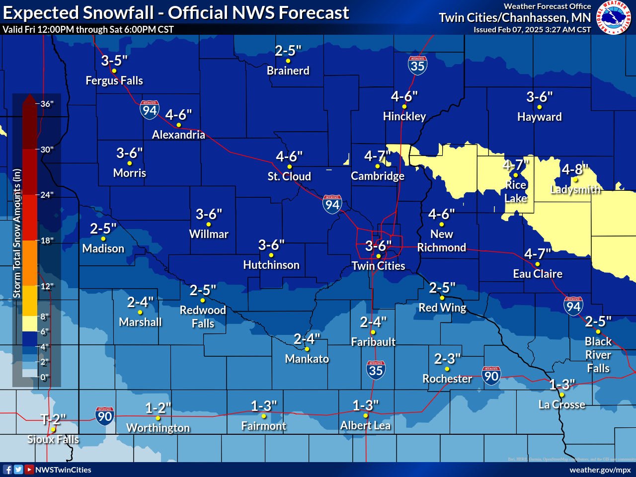
TWIN CITIES, MINNESOTA: The National Weather Service has issued a Winter Weather Advisory effective from midnight Friday until 6 PM CST Saturday. Snowfall accumulations are expected to range from 2 to 6 inches across the advisory region.
The affected areas include Mille Lacs, Kanabec, Sherburne, Isanti, Wright, Hennepin, Anoka, Ramsey, Washington, McLeod, Sibley, Carver, Scott, Dakota, Brown, Nicollet, Le Sueur, Rice, Goodhue, Blue Earth, Waseca, Steele, Pierce, and Pepin counties. Cities such as Minneapolis, St. Paul, Mankato, Monticello, Red Wing, and Owatonna will be impacted.
Timing and Impact
Snow is expected to begin in west-central Minnesota around 9-10 PM Friday and will spread to the Twin Cities metro area by midnight.
The heaviest snowfall will occur between midnight and 8 AM Saturday, tapering off from west to east through the morning and lingering into the early afternoon in western Wisconsin.
Road conditions will become hazardous due to accumulating snow, but wind speeds of 10 mph or less will limit drifting and blowing snow.
Travel impacts are anticipated overnight and into the early morning hours; however, conditions should improve as the day progresses.
Forecast Breakdown
Looking at the latest guidance, snowfall ratios are forecasted to range around 15-18:1, with localized areas reaching 20:1, which would be a fluffier snow accumulation. The heaviest snowfall is expected just north of the Twin Cities metro, along a line from Morris to St. Cloud to Barron, WI.
The snowfall ratio refers to the amount of snow that falls relative to the amount of liquid water it contains. The snowfall ratio also factors in temperature. The average snowfall ratio is a 10:1 ratio means 10 inches of snow would melt down to 1 inch of water, which occurs when temperatures are around 30F. In this storm, the 15-18:1 ratio indicates drier, fluffier snow, meaning 15 to 18 inches of snow would result from just 1 inch of liquid water, with temperatures forecast around 23-25F. Areas with a 20:1 ratio could experience even lighter, powdery snow, commonly seen in colder conditions, with temperatures near 15-18F. On the contrary, snowfall ratios that are 5:1 or 8:1 occur when the temperature is around freezing, or 32F. This is often called heavy wet snow or heart attack snow.
Precautionary Travel Measures
Residents are urged to exercise caution while traveling and to check road conditions before heading out. Minnesota road conditions can be found at 511mn.org, and Wisconsin road updates are available at 511wi.gov.
Stay tuned for updates as this winter storm progresses.
Latest Snowfall Forecast Totals from the NWS Twin Cities as of 3:27 AM on February 7, 2025
The above graphics were provided by the National Weather Service - Twin Cities.