
Twin Cities Severe Threat - May 28-30th
Updated at 12:00 PM - Monday, May 30: Updated discussion for the threat this afternoon and evening. Upgraded severe weather outlook.
Tornado Watch is likely within the next hour or so!
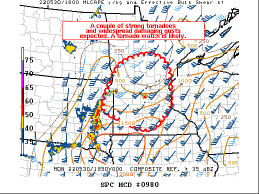
“SUMMARY...The threat of strong tornadoes and widespread intense gusts is increasing across extreme eastern South Dakota into southern/central MN. A tornado watch will be needed in the next hour.”
For more information of the full Mesoscale Discussion you can visit the following link:
https://www.spc.noaa.gov/products/md/md0980.html
Stormy Holiday Weekend
Click to jump down to [Today] Monday - May 30th for the latest severe weather threat discussion.
Instead of writing new articles every time and sharing the links, we are going to keep this blog as the main blog and continue to update this article with the latest information for the severe weather threat this weekend. You will be able to see when this article was last updated and what was updated from the time stamp above the severe outlooks above.
Saturday - May 28th (Updated - 11 AM, May 28th)
Showers and storms worked across the region early this morning and have since cleared out. Showers and storms are still forecast to develop over the Dakotas later today, but the latest guidance is showing these should weaken before reaching the area with the threat of strong to severe storms no longer expected.
Sunday - May 29th (Update 12 PM, May 29th)
Showers and storms this morning have worked out of the area. An outflow boundary from this activity was shed and additional showers and storms have developed along it to the north and northwest side of the Metro that is working off to the north-northeast. We will have to continue to monitor this activity this afternoon and into the evening hours as these could cause additional outflow boundaries and gradients to form over the area that could impact the outcome of additional development later this evening.
The stage is still set for a possible repeat of this morning late this evening as the latest model guidance shows the development of a linear cluster that is forecast to work into the Twin Cities region just after 10 PM. Damaging winds and hail will again be the main threat from these, but an isolated tornado threat can’t be ruled out.
Showers and storms then look to continue for much of the night, with possibly a second line of storms working across the region between 4-6 AM Sunday morning from the west-southwest. How much instability is left for these storms to work with we will have to see and will need to be monitored today and into tonight.
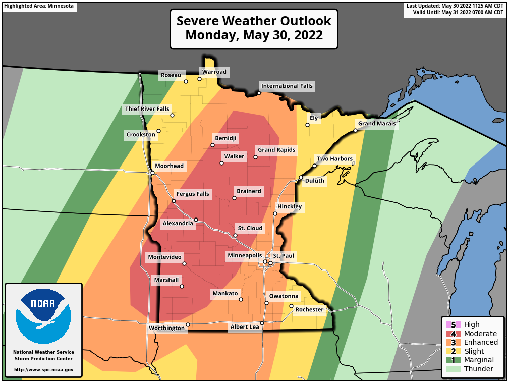
[Today] Monday - May 30th (Updated - 12 PM, May 30th)
Here is the latest update for the severe threat today across the Twin Cities Metro/Eagan. We fall under the Enhanced risk (3 out of 5) for severe weather today. The greatest threat time right now is between 7-10 PM. There is still some uncertainty in regards to storm mode, but models continue to hint at a line or broken line of strong to severe storms working through the region during that time.
The main threat will be damaging straight line winds up to 80 mph and large hail up to 2" in diameter. The environment is also favorable for a tornado or two, especially with any isolated supercells that could develop. That threat should manly be west of us for the supercells, but a few embedded tornadoes in the line definitely can't be ruled out.
Today is a day you want to heed the warning and act fast to it. Storm motions could be 55-60+ mph, so the storms potentially could be moving quickly. That means you won't have a lot of time between a warning issuance and taking cover. Have multiple ways to receive alerts today and be weather aware!

We will continue to monitor this threat and will continue to update this post over the coming days with the latest in regards to the severe weather potential this weekend. Be sure to have a plan in place in case severe weather does develop, and remember to be weather aware this weekend!