
Heavy rain, strong storms, and some drought relief are possible this weekend
Beginning this morning (Saturday, August 6th) and continuing through at least late Monday morning, August 8th, several rounds of showers and storms could bring some much-needed drought relief across parts of Minnesota and western Wisconsin. While there still lies some uncertainty on where the heaviest rain might fall, it appears a good part of the Twin Cities area might hopefully see some healthy rain over the coming days. Additionally, there is a threat of some strong to severe storms during the afternoon and into the evening hours today that will need to be monitored.
Periods of Heavy Rain, Strong Storms Possible
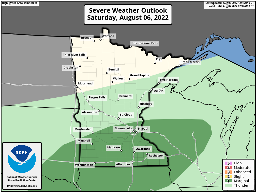
Light to moderate rain with an embedded storm or two will work into the Twin Cities Metro by early this morning. The latest model guidance has this rain gradually weakening by the time it reaches the Twin Cities, but light to moderate rain with an isolated rumble of thunder will is still possible by sunrise. As we get into the early afternoon, moisture and instability are forecast to increase, which will aid in the development of some locally strong to severe storms being possible. The main threat from these storms looks to be large hail and locally enhanced wind gusts. The greater threat for these strong to severe storms looks to be across the southern Suburbs and points south, but again an isolated strong storm can’t be ruled out. The Marginal Risk (1 out of 5) for severe weather is outlined in the first image above.
Additionally, periods of heavy rain could be possible within some of the stronger cells. As multiple rounds of rain are possible over the next couple of days and the overall storm motion for these is forecast to be fairly slow, there is a risk for localized flash flooding and standing water on roadways from these storms. So if you are out and about on Saturday into Sunday, watch for standing water on roadways and try to avoid driving into floodwaters if possible.
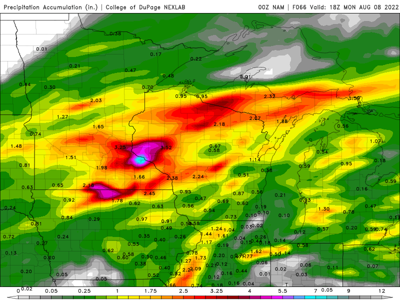
At this time, there remains some uncertainty as to where the region of heaviest rain and strongest storms might track because every round of showers and storms could impact later rounds of showers and storms. Currently, the northern cut-off for the heaviest rain is along the northern Twin Cities and points south. Guidance shows that 1-3 inches of rain could be possible across this area, with locally higher amounts possible where the heavier storms and any training of showers and storms could occur. In the second image above, you will see the forecasted precipitation total from the 00Z NAM model through Noon on Monday showing a bullseye of heavy rain near the Twin Cities and off to the southeast with around 2.00-3.25 inches of rain possible for a large chunk of the Metro. Again, this varies a little bit from model to model, though the general consensus is at least 1.00 to 3.00 inches of rain possible.
Much Needed Drought Relief
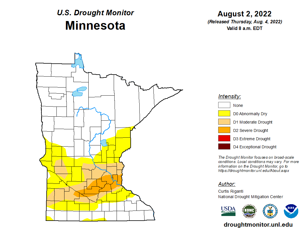
Taking look at the latest climate data from the National Weather Service for the Minneapolis [Twin Cities Metro] the month-to-date average precipitation is 0.7 inches below average with the average monthly precipitation usually around 0.86 inches. The 0.16 inches that we have seen so far came from the strong storms that rolled through around Midnight on Tuesday. The Metro’s year-to-date is sitting around 5.60 inches below normal with the normal being 19.76 inches. While the Twin Cities is in better shape by about 0.85 inches compared to last year at this same time, we continue to see an expansion of our D1 Moderate Drought and D2 Severe Drought across the Twin Cities as below normal precipitation occurred over at least the last month or so.
The rainfall we receive this weekend could make a big impact on the overall drought, it likely won’t take the Twin Cities completely out of the drought. It will at least begin the process of putting the Metro in the right direction to improve it as looking ahead at the latest Climate Prediction Center precipitation projections for the next 6-10 and 8-14 days, there is further good news! The latest predictions keep the Metro around average for precipitation going into at least the end of the month. Though we could return to a drier pattern between 2-3 months once again. This will be something we will have to continue to monitor over the coming weeks.